
GEOrgET logo
Recording many a track with GPS over the years and collecting heaps of data (as was also done on this trip, and hopefully, on some to come) means having to use GoogleEarth to view and edit the data. But GE has many a drawback, e.g. paths can’t be joined, or reversed, and GE’s automatic “tour” algorithm results often enough in simply bouncing around the countryside, instead of viewing it. Therefore it is with great pleasure that I can announce the publication of GEOrgET, the Google Earth Organiser, Editor and Toolkit. This is free software, licensed under the GPL, and resides here. Go download.
OK, it took a while longer to complete than originally planned. The last months have been spent trying to get my head around the SRTM altitude data and presenting it on maps that have contours, are shaded and coloured according to height. This also affects the compilation of GE tours that don’t crash into the ground—if you can determine how high the ground is under the drone, then you can avoid collisions with the former by making the drone fly higher. This proved to be quite the conceptual challenge, and I’m glad I’ve mastered it. And, of course, sometimes there was just some yakka to be done, i.e providing some documentation.
The result is a program that offers a number of functions to complement GE, and that has been tested on the track. It may not yet be completely idiot-proof (don’t overestimate the abilities of some idiots!), and for the time being it is on beta release, which I hope means that others will try it out and report back on things that don’t work as intended, and I will try to sort them out.
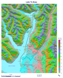
Lake Te Anau Cruise, from Te Anau Downs to Glade Wharf, or what GEOrgET makes of it. GPS data from the tracker, terrain altitudes via SRTM, and photo locations from the camera.
While developing the map making section of the program, one of the easier tasks was to include the photo locations on the maps, as well as a number of features such as rivers, lakes and islands. The GPS tracker that I’ve had since late 2009 came with a program to write the GPS data into each picture’s EXIF data. That struck me as rather useless, because looking at the numbers doesn’t really tell you where the picture was taken. But this map of the boat trip across Lake Te Anau to the start of the Milford Track, with all of the photos located along the cruise route, is worth more than a thousand words.
I have always been fascinated by the concept of using a single program to do different tasks, and with GEOrgET I have now written a program that not only detects that it has to install itself (and does so), but also rewrites itself during the process. This is one of the tightest conceptual curves I’ve driven around and I’m still a little dizzy.
GEOrgET joins a suite of PHP utilities that I carry around with me on the road (PHPlayground, also published on sourceforge, and the yet unpublished Purple Picture Processor, Pan2Cine, Interdraw, and Correctrix). However, the next project is to publish GEOrgET’s cities database on a platform (not WordPress) which will allow users to contribute to, and update it.
Onwards!