40. Te Anau—Dunedin

Ben & Lucy, Haddon Place, Dunedin, via airbnb; $49/night for spacious double bedroom, wifi, shared facilities
Thursday, March 14: Sunny and windy along the road with cloud increasing towards evening, quite a hot day
Go back! Wong Way, Te Anau

Go back! Wong Way, Te Anau

Everything repacked quite nicely and I was able to deal with breakfast fairly quickly and get down the road to take the photos that I wanted and to get to the library for the internet. Katie has a place for us tomorrow night (Dunedin Skeptics in the Pub), and Ilona was chattable. Continue reading


24. Nelson

The Palace
Tuesday, February 26: Cloudy at first, clearing somewhat and quite warm

Today was meant as a technical day, but there was certainly a lot to do. Breakfast at 8:00 was pretty empty (the hostel here provides one, at least) and I made my coffee and a bowl of cornflakes; then some toast for which I collected my vegemite.

Washing could only be done after 12:30, so I started on transcribing the hiking diary into blog format. Rearranged the TV room to get a comfortable enough seat for typing and downloaded at least some of the outstanding podcast episodes and finished transcribing two days. Guys came in every now and then to watch something on the telly, which was really helpful. Continue reading

17. North-West Circuit 10

North Arm – Oban (12.2 km) – Invercargill, Tina & Tony’s
Tuesday, February 19: Overcast, with some sun appearing in the afternoon
GPS Tour
Oban panorama from the pier

Oban panorama from the pier

Up fairly early in an attempt to make it onto an earlier flight. The last of the breakfast stuff was soon eaten and again there was enough coffee for two cups, though the sugar seems to have run out. A bag of salt was used to season the egg, and everything was packed up and ready to go by 9:00.

Lucas had already left a couple of minutes prior to me; then I was off on the very well graded and gravelled Rakiura Track. Not much mud here! A couple of stops for photos – mainly snapshots – some of which would be copies of the 2009 series. On the one long wooden bridge, the compass slipped out of its holding and bounced along the bridge. My heart nearly stopped beating. But in the end the device was safe. Continue reading

16. North-West Circuit 9

Freshwater River– North Arm, 11.3 km
Monday, February 18: Very cold overnight, some cloud in the morning clearing to sun
GPS Tour
North Arm across the mudflats

North Arm across the mudflats

It was so cold that the temperature must have gotten below what was allowed for the sleeping bag, so I had to put on the jumper to continue sleeping.

The HK alarm went off first, but no movement from the couple; then the German one went off so I decided it was time for breakfast. Not much left over except for coffee so I had a double shot. Then getting everything packed and ready to go. The HK couple were the first to be ready for their water taxi, and meanwhile Martin and I had taken apart the S-bend in the common room to try to remove the obstruction that was blocking water flowing down the pipe. Dismantled, emptied, but no change in the nett result, except for a bit of leakage. Continue reading

15. North-West Circuit 8

Mason Bay – Freshwater River, 14.0 km
Sunday, February 17: Drizzle overnight, cloudy in the morning, clearing to blue skies by afternoon
GPS Tour
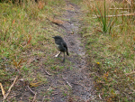
Cheeky Stewart Island Robin (Petroica australis rakiura)

Cheeky Stewart Island Robin (Petroica australis rakiura)

Most people were in bed or on their way by the time that the sun set. I was sharing with the Hong Kong couple who had gone to bed an hour or so previously; she was the only snorer but her snores grew weaker the longer the night. I was about the first to be up and finished with breakfast, then tried demonstrating the bracketed panorama to anyone who cared – that was mainly Julia (together with her lieutenant, Katrin I had had long discussions with yesterday evening and continued at breakfast). Then they were gone and I still needed to throw a few things into the pack, get a satellite fix and start my own day. Continue reading

14. North-West Circuit 7

View from the deck at Mason Bay hut

View from the deck at Mason Bay hut

Big Hellfire – Mason Bay, 17.0 km
Saturday, February 16: Fog, patches of drizzle; on the beaches strong winds; some brighter periods
GPS Tour

Up at around 8:00 and had two eggs, three muesli bars & a strong coffee for breakfast of the hardest day. The day was not looking promising but after sending off my signal with the spot tracker, I bid farewell to Bob & Ken, who were also leaving, and took off up the track. Continue reading

13. North-West Circuit 6

East Ruggedy – Big Hellfire, 15.0 km
Friday, February 15: Some drizzle at first, clearing, rain later on
GPS Tour
West Ruggedy Beach

West Ruggedy Beach

Got just over half a night’s sleep and was, of course, the first up and about, although I tried hard not to wreak revenge for last night’s events. Donna was up just as I had gotten my stuff together and I was ready to go.

Decided to split the day into four parts of (un-)equal time/distance divisions: 1) The track now leads via West Ruggedy Beach, so that was the first stage, including along the beach to the end; 2) From the beach end to the pass in the Ruggedy Mountains; 3) From there to Waituna Bay; and 4) finally to Big Hellfire. Continue reading

12. North-West Circuit 5

Long Harry – East Ruggedy, 9.9 km
Thursday, February 14: Rainy and windy overnight, a couple of light showers during the day
GPS Tour
Youtube video
East Ruggedy Beach and Sand Dunes. Hand-held panorama

East Ruggedy Beach and Sand Dunes. Hand-held panorama

Slept in until 8:30 this morning and quickly had breakfast and was packed and underway. Long Harry Hut has moved from its position on the old map to a position more to the east. From approximately its old site I could see the new hut but was unable to photograph it, as the camera was packed into the rucksack (as was most other stuff because of the rain). Continue reading

11. North-West Circuit 4

Yankee River – Long Harry, 8.4 km
Wednesday, February 13: Heavy showers overnight, mostly sunny during the day, short showers in the afternoon
GPS Tour
The easy end of Smokey Beach

The easy end of Smokey Beach

Had been latish into bed last night (around 10:00) and awoke just after 8:00. Feeling very sore from the last days’ hikes and can barely get around on the left foot. Packed everything up, cleared out the fireplace and swept the floor.

The track between Yankee River and Smokey Beach was possibly the worst in terms of mud. However, I was trying to take an easier pace, as I was in no hurry. Continue reading

10. North-West Circuit 3

Christmas Village – Mt Anglem – Yankee River, 19.7 km
Tuesday, February 12: A few light showers during the day, heavier in the evening
GPS Tour
Christmas Village in the morning

Christmas Village in the morning

Two snorers – the far worse was Ross, but Bernhard also joined in the concertino russamento. I slept until 1:00 before being awoken, and then I searched around for an aspirin, as I had a headache, but nothing could be found. Went out for a pee and heard a possum; then it was intermittent sleep until 6:30 when everyone got up and had breakfast. We were all going up Mt Anglem, but only I was going to attempt to get to Yankee River before the rain set in. Continue reading